This blog is inspired by a conversation I had with someone about how they often see cyclists cycling on the road along the front when, “There’s a cycle lane right there! Provided for their safety!” I advised I couldn’t comment on why those people on bikes she had witnessed were choosing the carriageway over the cycle lane but did go through some of the common issues.
The first thing I said was that there is no legal requirement to use a cycle lane (HWC61). Indeed, general guidance is that if you are travelling around 12-15mph or more it is better to be on the carriageway than a cycle lane or shared path. The lady I was chatting to admitted they did not know this and accepted that often the cyclists she saw were going just as fast as motor traffic and that a cyclists going nearly 20 mph may be a hazard to others on a shared path and so sensible to be on the carriageway instead.
I then went through some of the issues with the seafront cycle lane specifically, which I outline below. But first, a little something for those who don’t have the pleasure of living on the Essex Riviera.
The seafront cycle lane runs along the front (!) between Chalkwell and Shoeburyness, a distance of about 5 miles. It is designated as NCN16 yet does not connect with any other part of the National Cycle Network. It is bi-directional, running between the carriageway and pavement/promenade. It is probably the best piece of cycling infrastructure in the City of Southend (1) – for the bulk of the 5 miles it is separated from the carriageway and is clearly distinguishable from the pavement due to being a different height and painted green.
Southend seafront is predominantly a 30mph two-way road, with lots of through traffic. Between the pier and Southchurch Avenue it is a 20mph shared space where pedestrians, cyclists and motorists mingle freely.
So, if properly segregated, why do some people on bikes not use it? These could be reasons why.
Its width
It is designing for two-way traffic but really only gives a handlebar’s width each way. Generally this means having to slow for oncoming bikes just to ensure safety.(2) Safe overtakes can be hard too. Some parts of the lane have grassy verges and so one can utilise that for safety; other parts the lane has kerbs either side so hard to get as far over as one may wish. This gets even worse if using a cargo bike.(3)
It is not continuous
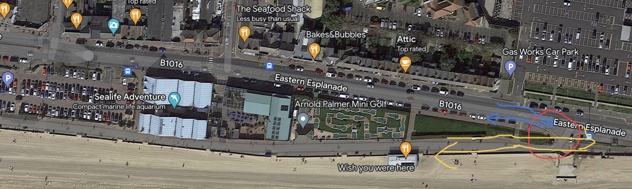
It stops either side of the pier. If one is cycling east, the cycle lane stops at Three Shells Beach, by the lagoon (the red circle in the photo below). Here, it directs you onto the pavement (following the blue arrow), which presumably has been designated as shared space. This pavement is quite wide but narrows as you go past the pier entrance and enter the 20mph shared space area. It isn’t clear where you are meant to go after this so most just cycle along the paved areas until you get to the other side of the pier where the segregated cycle lane re-starts.

If you are cycling west the cycle lane swerves into the carriageway by the gasworks car park (red circle in the photo below), forcing you into a 30mph busy road and then through a busy traffic-lighted junction (following blue arrow). Many people actually just ignore the lane at this stage and go onto the pavement/promenade (yellow arrow) but it would seem we’re meant to cycle onto the carriageway.
This lack of continuity can mean people stay in the carriageway, making better progress, rather than be leaving/re-joining traffic.
Its position
It is between carriageway and pavement/promenade on one side of the road. The position of the cycle lane does mean that if you want to turn off the seafront and head north (or indeed heading south and wanting to join the cycle lane) you have to cross two lanes of traffic. For many it is safer to just join the carriageway, particularly if only going a short distance along the front. It’s position is one of the reasons I feel it was built with pleasure riding in mind.
Chalkwell end
I consider this a death trap. If you are coming south down Chalkwell Ave you have to move from the left hand carriageway, across two lanes of traffic to join the lane (yellow line in the photo). Throw in a zebra crossing and a junction to contend with as well. So… safer to stay on the carriageway (green arrow), follow the road round and continue your journey without the hassle.


If you’re travelling west on the cycle lane, it stops and you join the carriageway right on a junction (my son approaching in the photo above) with nothing clear to indicate who has to give way… it looks like no one and it is two lanes suddenly merging beyond the zebra crossing on the bend.
Shoebury end
The last bit along Ness Road is actually shared space. If heading towards Shoebury you cross over New Barge Pier Road and paint markings direct you onto the carriageway – but you have to cross two lanes of traffic to do so. So it is easier and probably safer for you to not use the cycle lane if you join the seafront, say, at Thorpe Bay since you can just use the east bound side of the carriageway. The feeling here also is people cycling will want to go into Gunners Park, by turning right into New Barge Pier Road and have a bit of a ride in there. Again, a “ride for pleasure” thinking rather than a transport option.

General integration
Another thing that makes it feel a pleasure ride than transport is the general integration. It does not combine with any other cycle infrastructure. If you use it you will eventually be deposited back on the carriageway, so some may feel it is easier to stay on the carriageway.
Another integration consideration is how it interacts with the roads leading off the seafront and, to be fair, it is a game of two halves. The side west of pier is the issue. The side east of pier is better but there is one main junction that I will highlight.
West of pier – this is the stretch between Chalkwell and the pier. This is a semi-segregated cycle lane by virtue of a slightly raise kerb separating it from the carriageway (photo of my son below riding on it).(4)


Nowhere along this stretch is there a ramp to allow entry or exit at a point where the carriageway has a junction with another road. You have to mount or de-mount a kerb. Doing so at speed can damage wheels, so likely to slow down. This means you may be in the way of traffic for longer… Some can’t deal with kerbs due to their type of bike. A cargo bike isn’t great over them either. What this means is, if you are cycling along this stretch and want to head north it is easier to not use the cycle lane. Above is the junction with Shorefield Road. The yellow cross marks where something should be. The red and blue arrows indicate how the infrastructure pushes you. Below left is the junction with The Leas, and below right with Crowstone Ave. The point of highlighting these junctions is that to make these turns easier you either get off the cycle lane earlier or you don’t get on to the cycle lane at all.


East of pier – this is the stretch between the pier and Shoebury. This is better. The cycle lane here is on the pavement but sunk with kerbsides. This separates it from the carriageway and the pavement clearly. At most junctions there is a break in the kerb allowing entry/exit.(5) However, the junction with Thorpe Hall Ave does not have this. It is more of any issue if you are joining at this junction. In the photo below, the red, green and blue lines show a route joining from THA and heading west. The red is most sensible, joining the carriageway and getting onto the cycle lane as soon as possible (which is not in the photo and that bit circled in yellow is a floating bus stop which you can’t and shouldn’t be taking a bike through). When I do this I can get shouted at for not using the cycle lane. If you intend to head east then the easiest thing is to join the carriageway or do something similar to the blue or green lines. The purple shows how it is relatively easy to get off and head north up THA if coming from the east but the brown line shows the difficulties if heading from the west and wanting to go north.

Giving way
A tricky one – I don’t want to sound entitled in coming across that I shouldn’t have to give way to lots of things. However, there are lots of bits of the cycle lane where one has to give way, but the carriage way doesn’t. It has often been found that if a cyclist’s journey is impeded by having to give way all the time, they will make use of the carriageway where they have right of way. I have no issue with zebra crossings etc. It is when the cycle lane gives way but the carriage way doesn’t. They are both part of the road. The HWC generally says those not breaking direction have right of way (eg rule H3) . Why should a cyclist in the cycle lane, not breaking direction, have to give way to a side road when a driver in the carriageway doesn’t?
Some examples. First, in the Thorpe Hall Ave junction pictured above – note the bit that goes down to the beach (where the blue, purple and green lines meet). The cycle lane gives way here. Yet, no other traffic has to. Below are three more examples. Cyclists, according to the road markings, have to give way to motor traffic, yet this goes against the general principles of the Highway Code. If the cyclist was using the carriageway, they wouldn’t have to give way. Note the main picture – this is to allow boats to be taken over the road to the sea. Note the carriageway doesn’t have give way signs but the cycle lane does. Why the difference? Why do boats get a preference over bikes but not cars? The cycle lane is part of the road, yet one part of the road doesn’t have to give way to the boats but another does.


Car door risk
Some of the cycle lane is in between pavement and on road parking. There is the issue of being car doored by passengers of cars. There can often be people getting out of the car and leaving stuff on the cycle lane, eg buggies, something they wouldn’t even think of doing on the carriageway. I am not so uptight about this since if I had the choice of being car doored by a passenger or by a driver I would take the passenger. The driver side I am more likely to be pushed under motor traffic. Floating parking of this nature occurs in other cycling infrastructure in London, etc, and is probably a good compromise.
So, they are the things I have issue with on the seafront cycle lane. Some may seem them as petty or trivial, but humans like to take the easiest and most direct route. If you make on form of transport have to take more corners, stop more often and so on, you are inadvertently discouraging that form of transport. Ask yourself how often you have moaned about having to drive round a one-way system – yet you’re having to expend no energy in doing so. Once you are on a bike, you are using your own energy and so it should be made as convenient as possible.
Here is a video of me traversing the lane and routes around the pier the other day.
And, you may say, I’m moaning about it but not offering solutions. Well, my next blog will do just that!
Photos that include a bird’s eye view are taken from Googlemaps. They own the copyright etc.
Footnotes
1. All other cycling infrastructure is either magic paint or shared space, with the exception of the cycle lanes parallel to the A127, which are really just shared space (in some places shared with parked cars). The SFCL is the only cycling infrastructure in the City that feels properly segregated; however, to me, it also feels as infrastructure designed for a pleasure ride (come and park at Chalkwell, ride to Shoebury and back etc) and not part of an active travel network.
2. Compare this with the sheer number of roads that have cross hatching in the middle to keep two lanes of motor traffic apart so motorists don’t have to worry about this.
3. This could be read with a “so what?” attitude – so what if you have to slow because there’s oncoming traffic? Well, most carriageways are designed with lanes much wider than vehicles. Do you slow for all oncoming traffic when driving?
4. I don’t feel this is a very good design. The kerb would not stop a vehicle entering the cycle lane. When this photo was taken I was still hyper-vigilant.
5. Although, they are tight – in the video you can see me use one. They slow you down considerably, and not like many road junctions that allow motor vehicles to go through at speed.
